 |
|
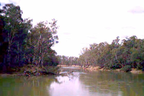
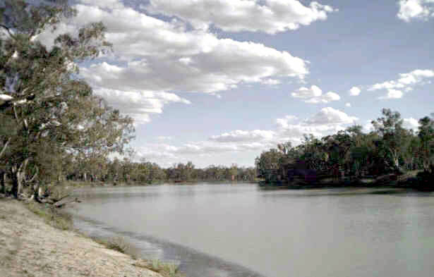
Barmah morning |
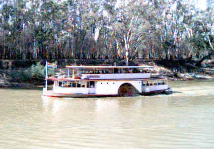
Paddle steamer Canberra |
Murray River Trip, March 24’th to April 6’th.
Mike and Gloria Osborne |
Discovery tdi200 |
Terry and Janice Miller |
Landcruiser |
Roy Bendal |
Discovery tdi300 |
Day 1: Canberra to the Barmah Forest. The day dawned fine, maybe even chilly for the time of year. We were in good time at the suggested rendezvous in the ACT border parking bay on the Barton highway. We had barely time for coffee and crumble before we had a complete party and were under way. The route was down the Hume highway to Holbrook to fill the tanks, then through Albury to the Ovens Valley highway to Milawa for lunch at Brown Brothers winery. The idea is that their "Epicurean Centre" presents dishes that complement their wines (or maybe the other way round). Whatever, a glass of an appropriate wine accompanies each dish ordered and the result is both interesting and pleasant. After a leisurely lunch, the bottle shop provided us with further supplies before we headed through Wangaratta to the Murray Valley highway. We turned off on the Picola road before entering the Barmah Forest by the Gulf road and heading along it and through the red gums to the Murray. The river here is currently pretty full, with the level being maintained high by water being supplied for summer irrigation purposes from the upstream dams. The gulf is a broad sweeping bend of the river and provides a good campsite (although there is no shortage of these). As the day had been fairly long that was good enough. Right by our campsite was the gulf regulator which allows water to enter the network of lagoons within the forest. It’s siteing must be pretty good because when opened the flow through it can drop the river height downstream by up to eighteen inches, and the height of the water in the lagoons of the Millewa forest on the opposite side of the river by twice that amount. This has not pleased the NSW foresters, and we heard a news report on the radio a few days later suggesting that a cooperative arrangement had just been reached for watering the forests. The red gums at the gulf are a favourite nesting spot for flocks of correlas and galahs. The result is a quite a din as they settle for the evening. For our benefit this was followed by a performance by kookaburras which just served to start off the correlas once again. It seemed like a good idea to try and get some sleep at the end of the second performance in case the cycle continued.
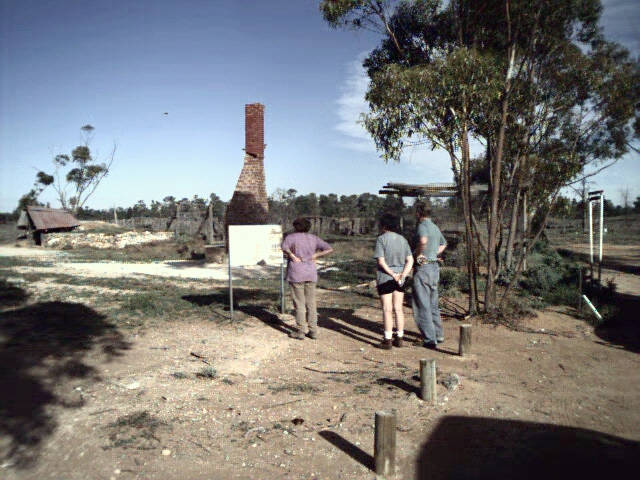
Day 2: Barmah Forest to Echuca. The kookaburras were in good voice again first thing, and their efforts contributed to a fairly early start. The evening had cooled down, and mist was rising from the river making a splendid picture with the rising sun shining orange through it down the east arm of the gulf. The water temperature proved pleasantly warm and invited a morning swim. Our route was along the River road to the Sand Ridge road to the Darnya Centre, a historical museum for the forest, which was "captured" by the Yorta Yorta people as one of the first actions resulting from the land rights decision. This is well worth a visit. Dramatic events have occurred here within recent historic times when a large block tilted (the Cadell tilt block) causing a ridge around 30 metres high to block the old bed of the Murray. The result was a lot of water looking for somewhere to go. The river split in two with the Edwards separating to the north and the present Murray to the south where it took over part of the bed of the Goulburn. The Barmah lake is a possible residual, and its banks provide the serviced camping area. Our recommendation would be the river bank. The road to Echuca crosses the Murray and then passes behind a north-south ridge for some kilometres – the only elevated
|
|
Barmah morning |
Paddle steamer Canberra |
ground for miles and presumably the remains of the tilt. The day was now fine and hot as we arrived at the Echuca caravan park at lunch time. In the afternoon we had to confirm our booking for the dinner cruise on the paddle steamer Mary Anne. This was indeed necessary because the cruise was well booked out. There was time to explore the port area before relaxing for an hour or so before dinner. The dinner cruise lasted for close to four hours and we got to watch a fine sunset on the river before the evening closed in. The dinner was somewhat mixed. The entrees were good, but three of the party were seduced by a menu item promising eye fillet. The resulting dish was clearly something else, and the result was not successful. Two of us had chicken dishes which were certainly OK, but the other problems did dampen the evening somewhat.
Day 3: Echuca to Nyah Forest. The agenda included a diversion to visit Kow swamp. This is an interesting lake which would seem to reflect the ground water pressures in the Kerang district. There are substantial outflows from this so called swamp for irrigation, much of it pasture irrigation which is one of the more dubious uses of irrigation water, while the inflows look marginal, and the dead trees in the water indicate a rise in water levels. There is not much scope for a dam to achieve the rise in this flat landscape. Our next destination was the Gunbower forest which is the next major stand of red gum downstream from Barmah. This appears a drier forest, and it has been extensively logged more recently. It proves to be not nearly so attractive, nor did we find the access road all that easy to find. We had lunch here on another sweeping bend. Escaping also proved a little difficult. Following on the river road we came, as expected, to a sawmill at the west of edge of the forest. Unfortunately, the bridge over the lagoon here was being rebuilt and was impassible. Finding an escape route required some improvisation using the most travelled track principle. This ultimately proved successful. Our route crossed the insignificant Barr creek which has been used as a drain in some attempted salination remediation work. As a result it ended up contributing some 10% of the salt in the Murray. Kerang is a serious salination area, and this is rather obvious from the highway. We stopped in Swan Hill for refuelling and supplies in mid afternoon, and then headed out to Nyah. Following the river road soon led us to an excellent camp site among big red gums by the river bank. The forest was in much better condition here although the river was well below the top of the bank so the use of regulators to fill the network of interior lagoons would be much more difficult than in the Barmah. Some very good steak was cooked to prove that it can be nice. With some coaching from Roy, the evenings were developing into wine tastings.
|
|
Lunch by the Murray |
Gunbower forest |
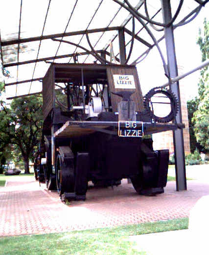
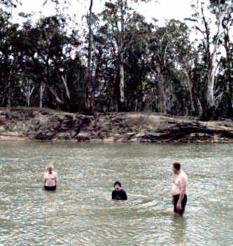
Day 4: Nyah Forest to Retail Bend. Traffic on the Nyah river road seemed to consist of gentlemen with exorbitantly luxurious flowing beards. Maybe there is a local competition? This morning my watch had given up the ghost for the last time! Red Cliffs was on our itinerary and provided some scope for a replacement. The route was along the Mallee highway to Ouyen (coffee stop) and then north on the Calder highway. The local attraction is Big Lizzie, a monster tractor originally designed in Melbourne around 1913 to cross sand hills in south western NSW in order to provide a reliable means for getting out the wool clip. In fact it never made it across the Murray, and only that far with considerable difficulty. But it earned its keep clearing soldier settler blocks in the Red Cliffs area after the first world war. In the end its top speed of about 2 mph made it less attractive as a work horse than the increasingly available motor vehicles. It is an interesting historic relic and well worth a visit. It is in a pleasant park that made an excellent lunch spot, the shade being appreciated on just about our hottest day yet. We planned a short afternoon heading down past the Mallee Cliffs to the Murray Kulkyne State Park. Mallee Cliffs is an area where saline ground water reaches the Murray and is (or has been suggested as) a site for remediation. Certainly we passed a battery of new pumps as we headed for the Park. The main tracks in the Park and the adjoining Hattah Lakes Park seem well signposted, but that was not our initial impression as there too many other (informal) tracks in what the GPS’s suggested were the right positions. However, we decided on Retail Bend and made it to a splendid beach and camp site. At least it was a splendid beach once several dead fish and one dead tortoise were buried and the air allowed to clear! The water was inviting and we all took advantage of the opportunity to have a swim. Forecasts suggested that the fine weather was about to end ("nuisance rain" was suggested for the Mallee).
 |
 |
Big Lizzie at rest |
Retail Bend provided excellent swimming |
Day 5: Retail Bend to Casuarina Camp. I took advantage of the river for the last swimming opportunity for several days. It was still largely dry as we packed camp, but it was clear the weather was changing for the worse. The rain started in earnest as we drove south through the Parks and turned onto the bitumen. We left the bitumen for the "Daytrap bus route" which skirts round the north side of Lake Tyrrell. This had an impressive white salt crust stretching into the distance, but something of a walk is needed to reach the shore and this idea was not too popular in the conditions. In fact there were strong representations from Terry (and not too much dissent from others) that a suitable shelter be found for morning coffee. It just so happened that this was available close by at the Nandaly sports centre which is now rather derilict although tennis is clearly still popular (and maybe golf). However, the football field hasn’t been mowed in a long time, a behind post leans alarmingly, and the saltbush is growing up through the concrete cricket pitch. The little towns losing population are rather sad, and three old ladies sheltering from the rain under the awning of the town's federation style general store would have made an atmospheric photo. The store has (had?) limited opening hours. Our route took us back through Ouyen which achieved greater strategic import when it was realised we could combine avoiding the rain with pies and sausage rolls for lunch. The Ouyen Bakery is proud to announce that it wins prizes for its vanilla slices. It was also the obvious place to top up fuel tanks. The turn for the Gunners track is just before Underbool on the Mallee highway and is posted Underbool – Patchewollock road. We ran south east and then south to the Wirengren Plain. The track was pretty good, becoming sandy and soft and crossing a succession of small dunes. Fortunately we were running out of the rain at the same time. A detour was made to Snowdrift, a spectacular white sand hill, before picking up the Meridian track and heading down to the camp. At this point we had the advantage of accurate directions from a couple of the Wyperfield National Park staff, and signposting within the park is pretty good. Before pitching tents we did some further recognoitering to check if the Freeway track was open (it wasn’t), and to check alternative camp sites. There was not too much wrong with Casuarina except for the proliferation of 1" high mounds with openings about the size of a 10 cents piece. Were they made by termites, spiders, or ants (large of course)? We saw lots more of these mounds but never came to a definite conclusion or, rather, to several different conclusions.
 |
 |
Snowdrift |
Round Swamp, Milmed Rock Track |
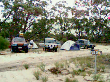
Day 6: Wyperfield NP to Pigeon Springs, Milmed Rock Track. The weather cleared by morning, and another fine warm day promised. We would anyway have to use the Moonah track, and it seemed likely that the Eagle track would provide an alternative route south within the park. This proved to be the case. Conditions were much as on the previous day, and easier than the last time I was here when the Moonah track was new (realigned?) and very soft, and the Eagle track was being cut. We reached the main camping area and park headquarters in comfortable time for morning coffee. This proved to be a palatial site with the latest in such modern facilities as composting toilets. Clearly the NPWS want to focus access into this area. Why? Most of the park is closed to motor vehicle access, and the area is not such as to encourage walking for much of the year. Its attractions are not obvious by comparison (say) with the Pink Lakes area to the north and lie in the flora and fauna. Interesting tracks such as the old nine mile square have been gated, yet sand hill country of its very nature is remarkably stable – even any creep is predictable and just one aspect of this stability. The plant species are equally well able to resist foreign, nonadapted, invasion in the area of their specialization, and soon recolonise old tracks. Next we had to find the southern end of Lake Albacutya. This lake relies on large floods in the Wimmera river for water to spill over from Lake Hindmarsh and has been dry for getting on twenty years. We stopped for lunch at the information bay, and were fortunate to get some up to date information on access to the Milmed Rock track from a local resident. This proved to be at variance with all the maps we have. These all agree in showing a route which now is interrupted by a ploughed field. To avoid this it is necessary to turn right (north) on a track where the sealed road turns hard left. There is a (small) track sign here. This track is followed to its join with a park boundary track which is then followed south west round the ploughed field until the Milmed Rock track (signposted) is reached. The boundary track continues on to provide the access to the Chinaman Well track. Our informant was not happy with the NPWS which has taken over a locally developed facility at the Albacutya west beach. He claims it is essentially closed down, and that this has impacted tourism which is increasingly important to areas such as this in current difficult times. For this reason he claims the Shire is trying to regain control. He also suggested we would find the Milmed Rock track distinctly rougher than those further north. This prediction proved correct. We crossed a succession of sand ridges on which the sand was deep, loose, and soft. Both Discoveries had to have several attempts at some of the ridges as a consequence. The route classification as easy was based on advice, but seems somewhat optimistic. There are some well signed landmarks at Round Swamp (this is shown on the 1 in 250,000 map which is otherwise uninformative), Milmed Rock (there is a rock, but its significance is that it is there rather than any particular size or formation, and there is also a visitors book), and Pigeon Springs. This latter made a pleasant treed camp site once we had found an area relatively free from burrs and bidgees.
 |
 |
Milmed Rock |
Camp site at Pigeon Springs |
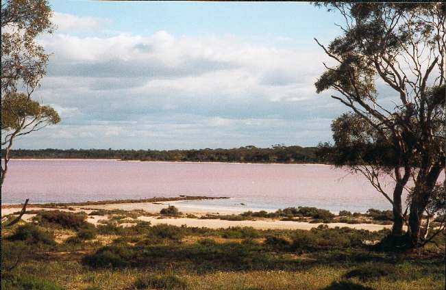
Day 7: Pigeon Springs to Mt. Crozier. Roy started the day by finding a particularly bright coloured correa reflexa (red tubes with prominent bright yellow ends) just round the corner from the camp site. The recce served another purpose – sand on the corner was deep and soft requiring care with cold engines. The last third of the track made fewer demands and we soon turned north on the Murrayville (pronounced murravil) track. The morning coffee stop was made at Big Billy where there are facilities, camping areas, and water. An information board promised that only tracks south of the White Springs track were not signposted. This track should have given us something of a short cut to Pink Lakes so we decided to take it. It proved an interesting route and there were no surprises until we reached its far end on the most southerly of a network of roads shown on all our maps. Any of the cross roads to the east indicated should have served our purposes well. The intersection was signposted south to White Springs and west to the Murrayville track. Our mistake was to turn east! Just as our entry to the Big Desert was complicated by the ploughing up of what should have been a clear track, so was the exit. Again the information on the 1 in 250,000 map was too out of date to make the GPS’s useful. By the time this sunk in we had found a track round the northern boundary of the park which tended to run east and north, the preferred directions. It also got rougher and rougher until it was little more than the recent tracks of some heavy equipment. More interesting, we were getting closer and closer to the smoke from fires ahead. By the time we encountered the foresters responsible we were close to the Gunners track. These took pity on us and escorted us back up the track (back involved climbing a substantial sand hill), through a gate they were using, and across private property to a road that led directly to Underbool. From Underbool it is a short step to Pink Lakes. Our viewing time was cut shorter than intended by the route finding problems, and the colour in the Lakes not particularly good, but we got to our intended camp at Mt. Crozier at a reasonable hour. So far we had kept to our schedule, but all that would change in the morning!
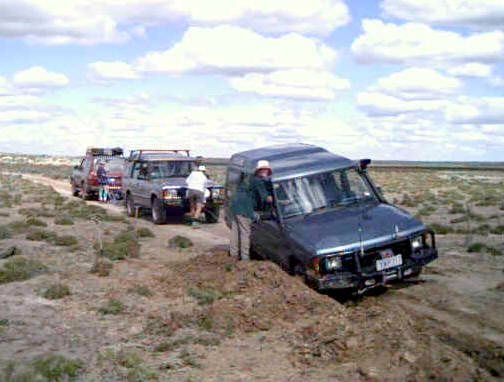
Days 8 & 9: Mt. Crozier to Mildura: Initially all went to plan. Trouble started on the edge of the Raak plain when my curiousity led us to follow what looked like recent car tracks heading north. We has barely gone a kilometre when the Discovery’s right front wheel broke through the surface crust and we were spectacularly bogged in an unpleasant liquid goo with a relatively thin covering of sandy material and with only the left wheels on firm ground. But a relatively minor problem had to be solved first with the Landcruiser also breaking through
 |
 |
Pink Lakes |
The last pull |
the surface. Roy’s winch was about to get a most thorough checking out. Roy could find a firm footing to free the Landcruiser, and this was accomplished relatively easily. The next problem was to find a similar firm footing to start pulling the Discovery. We used the Landcruiser to anchor Roy’s Discovery, and even when this was done we needed initially to extend the full winch cable with a drag chain to just reach the towbar on the bogged vehicle. On this extension there was no angle to pull it back onto the road so initially we were pulling it back in a straight line with right wheels off the firm surface. Each pull made only a few feet and the accumulated dirt then had to be cleared away. We tried different combinations of recovery strategies but without the ability to raise the vehicle to get firmer material under the wheels they were largely unsuccessful. This is one case where the flexibility and flotation of a bull bag might have proved useful. We even managing to break the drag chain in a snatch attempt (a blanket or tarpaulin over the cable is absolutely essential), but by then the towing vehicle was on firmer ground and the drag chain no longer necessary. This forced us to use shorter cables and encouraged us to use very short cables to try and establish an angle in order to pull the bogged vehicle more sideways. This gave some hope, but by now it was evening. After eleven hours work and 150 yards of dragging we pitched tents on the road and turned in. Nobody claimed to sleep all that well. Next morning a threat of possible rain had disappeared, and we continued mostly winching with the short cable. After four hours, 50 yards, and it seemed when we least expected it, the Discovery suddenly lifted, its rear right wheel came onto the road surface, and with one last effort of clearing and winching we were out. The Warn winch (9000lbs rating) had done a remarkable job. Lunch out on the road was a light hearted affair, but our itinerary now needed major surgery, and we decided as a first step to head for Mildura for hot showers and a change of clothes. We booked into the Apex (now River Bend) Caravan Park which is on the river a few kilometres west of downtown (take 7’th street west from the Sturt Highway and follow the signs). After cleaning ourselves thoroughly, and the Discovery somewhat, we decided on a light evening meal in town, but then Gloria decided we would try the Grand Hotel of "Gondola on the Murray" fame. Well we had a good dinner, but I am not sure that it was all that light!
 |
 |
Margaret Kelly with Roy |
The Murray at Lindsay Island |
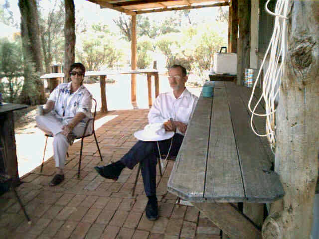
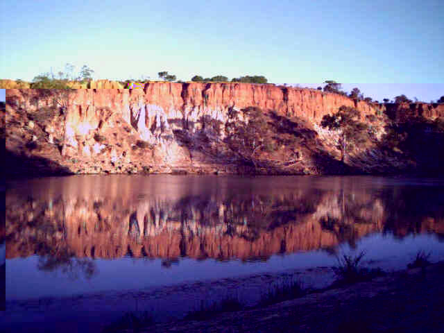
Day 10: Mildura to Lindsay Island. . I think we all slept very well. We made a leisurely start – especially Roy who couldn’t take seriously the proposition that the rest were having breakfast at McDonalds. We rendezvoused at the local Woolworths, and set off down the Sturt Highway. This time we were lucky! We had made extensive use of a beautiful little book "Discover Victoria’s Mallee" by Margaret Kelly. Privately published, it was recommended to me at the Melbourne Map Centre. All the information I had about Margaret was a Meringur address, and the cross reference that this was the home of the Millewa History Centre. I suspected there would be a connection. We had spent about an hour at the Centre, and were beginning to think about lunch, when Margaret arrived. There was a distinct element of chance in this because she no longer lives in the immediate area. We had a very enjoyable extended conversation in the course of which it emerged that she had also written a most attractive book on the wildflowers of the area (again privately published and her stock of copies is now exhausted), and that she had raised money for the Centre by leading wildflower tours. This activity has been curtailed by the NPWS who have been blocking vehicle access to her favourite areas. However, she has not given up hope that compromises could be arranged, and she would be very happy to show us around. That suggestion has a very definite appeal. LRC please note! This was another instance where NPWS activities were frustrating activities which had the potential to bring tourists to the area and assist the local economy. Margaret suggested that part of the problem was the relatively short term of appointment of officers to this wide ranging and complex region. We left for Lindsay Island somewhat reluctantly, and a route change was needed. A transport had gone through the surface of the Meringur North road after the rains. We learned they had had an exceptional 10 inches within the last two weeks. We made the Island without further incident and headed west down the Sandford track. We turned right to the Murray down the Old Phone Line track (the reason for the name proved obvious), and set up camp on the river bank opposite the Kulkurna Cliffs. There is a property just upstream of the cliffs on the NSW side of the river. Fortunately they did not run their generator all night. However, it probably would not have mattered on this occasion. It seemed a good occasion to sample the Tokay collected at Brown Bros.
 |
 |
| Kulkurna Cliffs at sunrise | A lonely grave on the Renmark mail route |
Day 11: Lindsay Island to Mungo NP. It seemed likely that the cliffs opposite would be distinctly photogenic in the early morning sun, and this provided the excuse for some relatively early rising. The water was quite pleasant for swimming as well, although I didn’t have much company. We took an alternative track, closer to the river, on the way back. All went well until we reached a recently bulldozed airstrip when it essentially disappeared. This kind of activity seems endemic in this region! We did find a way round, and picked the track up again on the other side of some obviously related buildings, and then followed it out without further incident. We headed down the Renmark mail route, stopping for coffee in shade by a lonely memorial to a tragic drowning accident. The mail route ends at, of all things, the Meridian track – now nicely sealed – and we had an easy run into Wentworth for lunch at the junction of the Murray and Darling. Gloria needed further ammunition for the Gloria versus Janice culinary Olympics and found the Wentworth supermarket very satisfactory. Diesel prices were coming down, and we received information that our proposed route would likely encounter track closures along with graphic descriptions of damage done by the rain. For this reason we decided to head for Pooncarrie on the bitumen with the intention of taking the Mungo turnoff. This proved to have a road closed sign on it so we proceeded to Pooncarrie to get information on alternative routes. We finished up cutting across to the Darnick road and following this down. It was getting later than intended when we reached Mungo, so we put tourist activities on hold and headed across to the camp site behind the Walls of China. Gloria made a formidable play with a Thai style chicken curry accompanied by a Tatachilla rhine reisling and followed by cheese and Tokay. I had had obvious trouble with the camera at Meringur and fitted new batteries. Downloading to the BBP gave more evidence. Some fancied shots were just missing. I should have picked up the problem earlier when I was puzzled by the need to strongly emphasize the brightness when editing earlier pictures.
Day 12: Mungo NP to Willandra NP. Roy was the only first timer at Mungo, and the others were more interested in hot showers at the Park headquarters than a visit to the Walls of China. So we let Roy in early and sent him off while we relaxed. He came back with a story that visitors were now required to remove their shoes while inspecting the wind sculptures. I am afraid we were a bit incredulous. Our route out saw us retracing our steps to the Mosgiel to Hillston road. This was in fair condition, and we arrived at Willandra in early afternoon. We spent quite a bit of time exploring the shearing sheds and then the homestead. We have been pleased to watch the restoration work from the dark days when it seemed the station was to be allowed to sink into the black soil plains. Now the sheds have been painted, and the homestead restoration is at a seriously advanced stage with new plumbing being fitted while we were there. Soon it is intended that it will be possible to stay in the homestead. The ranger was rather pleased to see us. It seems we were the first visitors for some time, but we did have company – the first time since Barmah. The latest play in the culinary Olympics consisted of meat pies followed by
 |
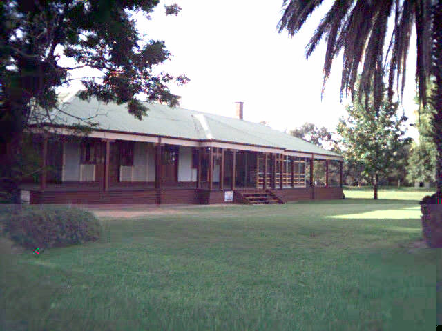 |
| Zansi Station, Mungo NP | Restored Willandra Station |
apple pie and cream cooked by Janice in camp ovens. They were great! There is a lot to be said for encouraging this kind of competition!
Day 13: Willandra NP to Cocopara NP. It was a bit of a surprise to discover that a walking track beside the Lachlan anna branch that used to be recommended for bird watching seems to have disappeared. Flood damage maybe? For exercise we walked across to the weir and back to camp before setting off for Griffith. This destination served two purposes. Gloria has an outlet there for her glass jewelry, and I had promised Terry a baker with sausage rolls. Roy was concerned to correct our pronunciation of De Bortoli just in case we followed him to the winery. Perhaps it was just as well because follow we did, and we came away with some trophies to prove it. It was only a few more kilometres to the Whitton Stock Route turn off. A bit over twenty kilometres more and we were at our final camp site. The weather threatened rain, and even sprinkled enough to encourage us to put up tent annexes, but nothing serious eventuated.
Day 14: Cocopara NP to Ardlethan. It was back to the highway and on to Ardlethan for an early coffee. We hadn’t planned anything special, but it was unexpected to find the "Ardlethan Arts and Internet Cafe ". We spent a good deal more time there than anticipated – well worth a visit. Gloria even came away with a commission. Our paths separated here. Roy to take the shortest way home, Terry and Janice to visit family in Orange, and us to Wagga where Gloria had an afternoon appointment at the art gallery. It was yet another fine, warm day.